Progress
Complete.
Reason for development
To addresses the lack of basin characterisation and classification specific to the Canadian prairies.
Applications
Many potential applications. The classification helps us understand how different watershed classes function. This provides a consistent, reliable underpinning for different modelling exercises including; response to changing climate, response to changes in land-use, surface water nutrient loads, fate of pesticides, and biodiversity.
Summary
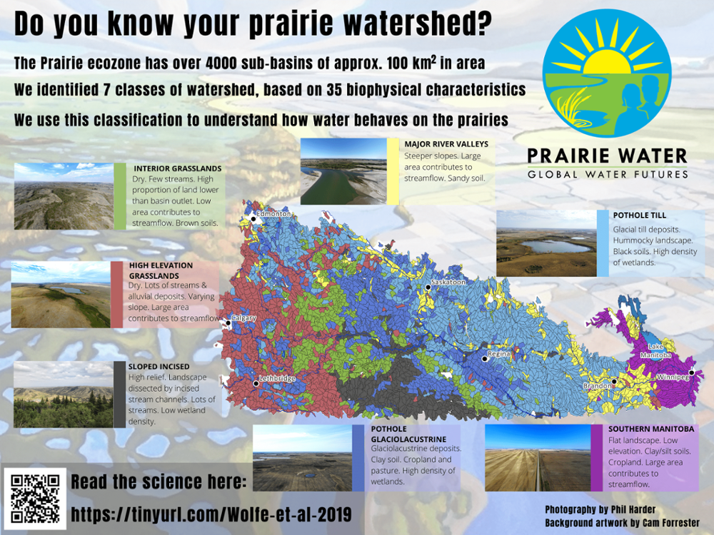
The Prairie Watershed Classification is perhaps the most important piece of work to come out of the Prairie Water Project. Watershed classification approaches are widely used in other regions. However, these approaches are not well suited to the Canadian Prairies. Existing watershed methods rely on hydrological parameters, and therefore require well-developed hydrological records, which do not exist for the Canadian Prairies. Existing methods also rarely account for hydrological systems which have no outflow, which is the case for large parts of the Prairies. Hydrology on the prairies has also been significantly modified by human activity, complicating the use of only hydrological variable in watershed classification.
Prairie Water identified the lack of an effective method of classifying prairie watersheds as one of the key challenges in understanding and modelling how water behaves on and under the prairie landscape. One of our first objectives was to fill this gap, and by doing this, provide a solid foundation for much of our research into prairie hydrology, ecology, biogeochemistry, economics, and other science.
Our prairie watershed classification approach looks beyond hydrological parameters. We identified watershed boundaries using the HydroSHEDs global dataset (Lehner and Grill, 2013). The watershed classification includes 33 climate, geological, topographical, and land-cover parameters that we found were key variables in predicting watershed response. This classification approach has been peer reviewed and published in the Hydrological and Earth Systems Science journal (LINK).
Using this classification approach, we identified 7 distinct watershed classifications using the HydroSHEDS boundaries. The infographic below visualises the distribution of these watershed classes across the over 4000 sub-basins across the prairies. Having these basins classified and parametrised in this way allows us to model how changes in climate and land-use is likely to impact water resources at local and regional scales.