
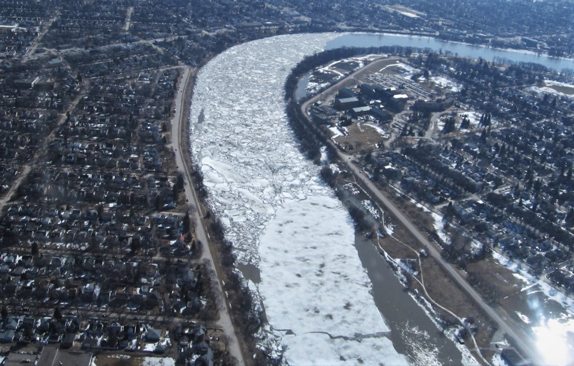
A4 develops and integrates modelling and remote sensing tools to simulate the impact of climate change on river ice processes, including ice jam flooding, by using RIVICE in conjunction with MESH and the Gem-Hydro forecasting system. Since river ice processes are stochastic in nature, RIVICE is embedded in a Monte Carlo framework to provide ensembles and a probabilistic description of flood water levels. Through IMPC, the MESH-RIVICE integration will be tested and applied in the Peace-Athabasca Basin in the Mackenzie, the Saint John River in New Brunswick/Maine/Quebec, and the Churchill and Exploits rivers in Newfoundland and Labrador. In maritime climates, the methodology is extended to include free-up and mid-winter ice-jam flooding. Through GWF Core Modelling, we develop a geospatial model that clusters geomorphological, hydraulic and meteorological features of rivers and correlates the clusters to river reaches that have a propensity of ice jamming, given current hydro-meteorological conditions. The extended modelling system, MESH-geospace-RIVICE, will allow focused simulations of ice jamming with RIVICE to establish ice-jam flood risk along vulnerable river reaches across Canada.
Area of focus:
- Peace-Athabasca Basin in the Mackenzie
- Saint John River (New Brunswick-Maine)
- Churchill river (Newfoundland and Labrador)
- Exploits River (Newfoundland and Labrador)
- Red River (Manitoba)
Model in use:
- MESH-geospace-RIVICE
Dr. Karl-Erich Lindenschmidt, Modelling Riverine Processes
In the News
|
|
IMPC Investigator Predicting River Ice Jams, The "Black-Box" of Flood ForecastingDr. Lindenschmidt is collaborating with Manitoba Infrastructure to forecast Ice-Jams along the Red River using his RIVICE Model. Read more... December 3, 2019 |
|
|
Year 1: Extend MESH-RIVICE to explore freeze-up and mid-winter breakup ice jams, both in natural and regulated river systems.
Year 2: Validate MESH-GeoSpace-RIVICE system (from Core Modelling) for these natural and regulated river systems.
Year 3: In an ice-jam flood forecasting context, implement MESH-GeoSpace-RIVICE in a platform which allows data streaming and flood warning issuances
Progress so far:
(i) Coupling of MESH-RIVICE for testing for role of regulated/re-naturalized flows and reservoir operation on ice-jam flooding in Peace River and evaluation of river ice processes in future climate in Athabasca River;
(ii) The forecasting system has been introduced operationally at Fort McMurray, Alberta and the lower Churchill River by the Government Newfoundland and Labrador's forecasting system for the lower (Atlantic) Churchill River. This is the first operational ice-jam flood forecasting system to have been implemented world-wide.
Lead:
 |
Karl Erich-LindenschmidtAssociate Professor |
Co-Leads:
 |
Al PietroniroExecutive Director
|
Highly Qualified Personnel:
|
Prabin Rokaya Postdoctoral Fellow |
Research: Hydrological modelling; River ice modelling |
|
|
Zhaoqin Li Postdoctoral Fellow |
Research: Remote Sensing |
|
|
Brandon Williams Research Assistant |
Research: Hydrological modelling; River ice modelling |
|
|
Sujata Budhathoki Research Assistant |
Research: Hydrological modelling |
|
|
Manitoba Infrastructure |
|
|
Government of Yukon |
|
|
Mackenzie River Basin Board (MRBB) |
| Manitoba Hydro | |

- Dr. Lindenschmidt recently published his book, River Ice Processes and Ice Flood Forecasting: A Guide for Practitioners and Students, that describes theory and application of the RIVICE model for a given river. Buy this book here.
Selected Publications
-
Lindenschmidt, K.-E., Rokaya, P., Das, A., Li, Z. and Richard, D. (2019) A novel stochastic modelling approach for operational real-time ice-jam flood forecasting. Journal of Hydrology 575: 381–394. https://dx.doi.org/10.1016/j.jhydrol.2019.05.048 (IF = 3.727)
-
Lindenschmidt, K.-E. and Rokaya, P. (2019) A stochastic hydraulic modelling approach to determining the probable maximum staging of ice-jam floods. Journal of Environmental Informatics 34(1): 45-54. https://dx.doi.org/10.3808/jei.201900416 (IF = 4.521)
-
Lindenschmidt, K.-E., Carstensen, D., Fröhlich, W., Hentschel, B., Iwicki, S., Kögel, K., Kubicki, M., Kundzewicz, Z.W., Lauschke, C., Łazarów, A., Łoś, H., Marszelewski, W., Niedzielski, T., Nowak, M., Pawłowski, B., Roers, M., Schlaffer, S. and Weintrit, B. (2019) Development of an ice-jam flood forecasting system for the lower Oder River – requirements for real-time predictions of water, ice and sediment transport. Water 11: 95. https://dx.doi.org/10.3390/w11010095
-
Lindenschmidt, K.-E. and Li, Z. (2019) Radar scatter decomposition to differentiate between running ice accumulations and intact ice covers along rivers. Remote Sensing 11: 307. https://dx.doi.org/10.3390/rs11030307 (IF = 4.118)
-
Lindenschmidt, K.-E., Huokuna, M., Burrell, B.C. and Beltaos, S. (2018) Lessons Learned from Past Ice-Jam Floods concerning the Challenges of Flood Mapping. International Journal of River Basin Management 16(4): 457-468 https://dx.doi.org/10.1080/15715124.2018.1439496 (IF = n/a)
-
Chu, T. and Lindenschmidt, K.-E. (2019) Effects of river geomorphology on river ice freeze-up and breakup rates using MODIS imagery. Canadian Journal of Remote Sensing 45(2): 176-191. https://doi.org/10.1080/07038992.2019.1635004 (IF = 2.553)
-
Rokaya, P., Morales, L., Bonsal, B., Wheater, H., Lindenschmidt, K-E. (2019) Climatic effects on ice phenology and ice-jam flooding of the Athabasca River in western Canada. Hydrological Sciences Journal 64(11): 1265–1278. https://doi.org/10.1080/02626667.2019.1638927 (IF = 2.180)
-
Rokaya, P., Peters, D., Bonsal, B. Wheater, H. and Lindenschmidt, K.-E. (2019) Modelling the effects of flow regulation on ice-affected backwater staging in a large northern river. River Research and Applications 35: 587-600. https://dx.doi.org/10.1002/rra.3436 (IF = 2.067)
-
Rokaya, P., Wheater, H.S. and Lindenschmidt, K.-E. (2019) Promoting sustainable ice-jam flood management along the Peace River and Peace-Athabasca Delta. Journal of Water Resources Planning and Management 145(1): 04018085. https://doi.org/10.1061/(ASCE)WR.1943-5452.0001021 (IF = 3.537 in 2016)
-
Zhang, F., Li, Z. and Lindenschmidt, K.-E. (2019) Potential of Radarsat-2 to improve ice thickness calculations in remote, poorly accessible areas: a case study on the Slave River, Canada. Canadian Journal for Remote Sensing 45(2): 234-245 https://doi.org/10.1080/07038992.2019.1567304 (IF = 2.553)
-
Rokaya, P., Budhathoki, S. and Lindenschmidt, K.-E. (2018), Trends in the Timing and Magnitude of Ice-Jam Floods in Canada, Scientific Reports 8: 5834. http://dx.doi.org/10.1038/s41598-018-24057-z
-
Rokaya, P., Budhathoki, S. and Lindenschmidt, K.-E. (2018) Ice-jam flood research: a scoping review. Natural Hazards 94(3): 1439–1457. https://dx.doi.org/10.1007/s11069-018-3455-0 (IF = 1.901)
-
Das, A., Reed, M. and Lindenschmidt, K.-E. (2018), Sustainable ice-jam flood management for socio-economic and socio-ecological systems. Water, 10: 135 http://dx.doi.org/10.3390/w10020135
-
Li, Z. and Lindenschmidt, K.-E. (2018), Coherence of Radarsat-2, Sentinel-1, and ALOS-1 PALSAR for monitoring spatiotemporal variations of river ice covers, Canadian Journal of Remote Sensing 44(1): 1-15. https://doi.org/10.1080/07038992.2018.1419424
-
Lindenschmidt, K.-E. (2017), Modelling probabilities of ice jam flooding from artificial breakup of the Athabasca River ice cover at Fort McMurray. CGU HS Committee on River Ice Processes and the Environment, 19th Workshop on the Hydraulics of Ice Covered Rivers, Whitehorse, Yukon, Canada, July 9-12, 2017. http://cripe.ca/docs/proceedings/19/Lindenschmidt-2017.pdf
-
Das A., Rokaya, P. and Lindenschmidt, K.-E. (2017), Assessing the impacts of climate change on ice jams along the Athabasca River at Fort McMurray, Alberta, Canada. CGU HS Committee on River Ice Processes and the Environment, 19th Workshop on the Hydraulics of Ice Covered Rivers, Whitehorse, Yukon, Canada, July 9-12, 2017. http://cripe.ca/docs/proceedings/19/Das-et-al-2017.pdf
-
Liu, N., Kells, J. and Lindenschmidt, K.-E. (2017), Two-way fluid-structure interaction model of waves propagating in a channel with an ice cover. CGU HS Committee on River Ice Processes and the Environment, 19th Workshop on the Hydraulics of Ice Covered Rivers, Whitehorse, Yukon, Canada, July 9-12, 2017. http://cripe.ca/docs/proceedings/19/Liu-et-al-2017.pdf
-
Rokaya, P., Das, A. and Lindenschmidt, K.-E. (2017), Exploring flow operation schemes for sustainable ice-jam flood management along the Peace River in western Canada. CGU HS Committee on River Ice Processes and the Environment, 19th Workshop on the Hydraulics of Ice Covered Rivers, Whitehorse, Yukon, Canada, July 9-12, 2017. http://cripe.ca/docs/proceedings/19/Rokaya-et-al-2017.pdf
-
Warren, S., Puestow, T., Richard, M., Khan, A.A., Khayer, M. and Lindenschmidt, K.-E. (2017), Near Real-time ice-related flood hazard assessment of the Exploits River in Newfoundland, Canada. CGU HS Committee on River Ice Processes and the Environment, 19th Workshop on the Hydraulics of Ice Covered Rivers, Whitehorse, Yukon, Canada, July 9-12, 2017. http://cripe.ca/docs/proceedings/19/Warren-et-al-2017.pdf
-
Zhang, F. and Lindenschmidt, K.-E. (2017), River ice hydraulic modeling of the Slave River Delta. CGU HS Committee on River Ice Processes and the Environment, 19th Workshop on the Hydraulics of Ice Covered Rivers, Whitehorse, Yukon, Canada, July 9-12, 2017. http://cripe.ca/docs/proceedings/19/Zhang-Lindenschmidt-2017.pdf
-
Das, A. and Lindenschmidt, K.-E, (2018) Evaluation of the relative sensitivity of hydraulic model parameters and boundary conditions and Digital Elevation models on ice-jam flood delineation. 39th Canadian Symposium on Remote Sensing, Saskatoon, Saskatchewan, Canada, 19-21 June, 2018
-
Das, A., Rokaya, P. and Lindenschmidt, K.-E. (2018) Impacts of Climate Change on Ice-jam flooding along a northern river, Canada. Cryospheric Extremes Workshop, Helsinki, Finland, 26-28 April 2018.
-
Li, Z. and Lindenschmidt, K.-E. (2018) Monitoring river ice cover development using the Freeman-Durden decomposition of quad-pol Radarsat-2 images. Global Water Futures inaugural meeting, Hamilton, Canada, 4-6 June 2018.
-
Li, Z., Zhang, F. and Lindenschmidt, K.-E. (2018) Integrating Radarsat-2, air photos, and environmental data for estimating river ice volume as an essential input for near-real time ice-jam flood forecasting. 39th Canadian Symposium on Remote Sensing, Saskatoon, Saskatchewan, Canada, 19-21 June, 2018
-
Rokaya, P., Lindenschmidt, K.-E., Budhathoki, S. and Das, A. (2018) Ice-jam floods: Recent trends and patterns. Cryospheric Extremes Workshop, Helsinki, Finland, 26-28 April 2018
-
Zhang, F., Li, Zhaoqin, L. and Lindenschmidt, K.-E. (2018) Potential of RADARSAT-2 for improvement of an ice thickness model: a case study on the Slave River at Fort Smith, Alberta. 39th Canadian Symposium on Remote Sensing, Saskatoon, Saskatchewan, Canada, 19-21 June, 2018