
Turning Data into Actionable Knowledge
IMPC launches pilots of its Decision-Support System and Data Visualization tool designed to make cutting edge water science research in Canada accessible to the public.
By Laila BalkhiIn water science research, there are often known knowns and known unknowns - meaning that there is information we already have, and other information we know we need but don't have yet [i]. But the two types of information translate somewhat differently in the domain of policy-makers or decision-makers who might not be water scientists. In these circles, there are usually unknown knowns and unknown unknowns - information that scientists may have but decision-makers aren't aware of, and information that decision makers don't even realize they don't have nor they understand well.
Researchers have been pondering over this gap between quantitative data science and decision-making since the 60s [ii]. Hence began the systematic study of computerized Decision-Support Systems, and online visualization tools meant to bridge the knowledge transfer gap.
The Integrated Modelling Program for Canada (IMPC) is working on a few platforms that transfer scientific findings into visual tools to help decision-making, disseminate knowledge, and engage curious 'netizens'. IMPC is the largest-funded of the 39 projects under the Global Water Futures program that aims to deliver risk management solutions and innovative decision-making tools informed by leading-edge science.
The IMPC team recently released the pilot versions of a decision-support platform and a data visualization tool that are currently under construction to help turn data into actionable knowledge.
IMPC’s User-Centric Decision Support System simulates water flow within the South Saskatchewan River Basin. The user interface is designed with a diverse audience in mind. So whether you're a high school student or a hydrological engineer, the tool is easy to use and provides valuable insight into the Saskatchewan basin waters.
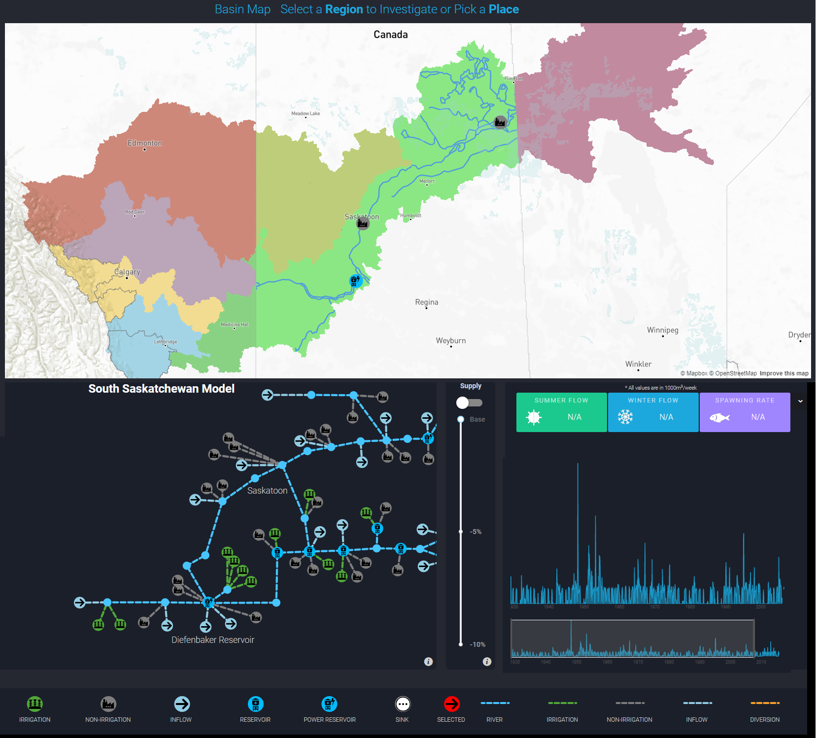
IMPC User Decision Support Platform viewing South Saskatchewan River Basin
The tool uses water models that incorporate economic and environmental values developed under IMPC Theme B to track water flow through the basin. The platform depicts major water supply sources (inflow into the river) and water resource users downstream. A river tributary adds to the river flow, whereas irrigation or power plants etc. withdraw water out of the system. Users can then visualize how water flow in different parts of the river change under various water supply scenarios.
For example, decreased water supply upstream might affect spawning rates for different fish species, impact provincial gross domestic product (GDP), or alter operations and infrastructure downstream and so on. These scenario projections will be directly informed by IMPC Theme C research. The tools also allows for a 'deep-dive mode' for eager water scientists or students to explore the back-end mechanics of how the model calculates water information.
Once the system design is complete, the Decision Support platform will also let users explore cultural impacts on changing water flows over time. The computerized map will feature multi-media images of various important regions, describing changes to the landscape and its connection to communities and livelihoods.
The DAta VISualization Tool, or “DAVIS”, is geared more towards the visualization of quantitative data over an interactive geographical map. The tool will feature data on rain, evaporation, temperature, river flows and glacier melt that can be visualized over a period of time. Users can also upload small amounts (megabytes) of their own data to see it distributed over a region or time span on the online tool.
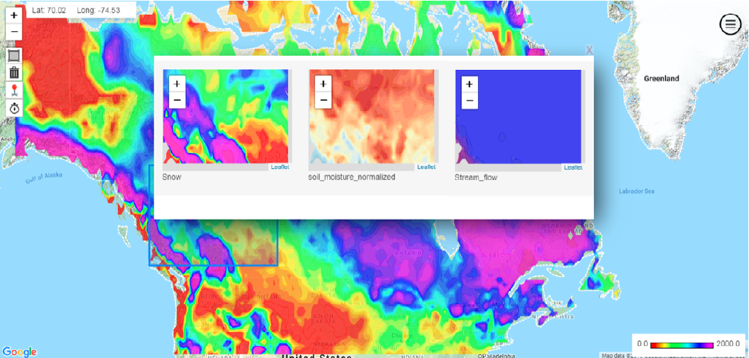
Visualization of VIC model outputs for a given area using DAVIS
Computer scientists working on this tool will be updating these platforms with new features and capabilities over the course of the IMPC project in the next couple of years. Researchers are hoping that bringing together the natural and human dimensions of our water management landscape on user-friendly platforms will allow for a more holistic understanding of our resources and gaps in knowledge.
The Integrated Modelling Program for Canada (IMPC) is a transdisciplinary research program bringing together scientists and stakeholders from six Canadian universities, twelve government agencies and more than ten end-user communities. This team provides a unique expertise that integrates atmospheric science, hydrology and ecology with social science, computer science, economics, and water resource engineering. Follow this link to explore more.
[i] The “known” and “unknown” framework of categorize different types of human intelligence is known to have been used since the Greek era (see Socratic paradox) to explore questions around information considered common knowledge, awareness of assumptions, biases and unconscious decisions, and consciousness of questions not asked or explored yet. The framework has since been used as a way of understanding human intelligence in various areas of research such as climate change, biology, psychology, design etc. The play on the words, however, is most commonly associated with Donald Rumsfeld’s speech, as Secretary of Defense in 2002, regarding US information on Iraq.
[ii] Power, D. J. (March 10, 2007). “A Brief History of Decision Support Systems” | DSS Resources. Retrieved online from https://dssresources.com/history/dsshistory.html