
CHM
The Canadian Hydrological Model (CHM) is a spatially distributed, modular modelling framework. Although not restricted to cold regions, it is designed with both cold-region and temperate zone processes in mind and has various capabilities that facilitate the modelling of these domains. The design goal of CHM is to use existing high-quality open-source libraries and modern high-performance computing (HPC) paradigms. By providing a framework that allows for as loose or tight a coupling between processes as required, CHM allows for the integration of current state-of-the-art process representations and makes no assumptions about the complexity of these process representations. For example, it allows for the testing of the representations in a consistent manner, diagnosing model behaviour due to parameter changes, process representation changes, and basin discretization. Spatially, it allows for domains at point (10−6 km2), hillslope (1 to 10 km2), basin (100 km2), regional (8000 km2), and provincial or state (> 1 000 000 km2) scales. The following sections outline the framework features, including terrain representation, surface parameterization, process representation, meteorological inputs, parallelism, uncertainty analysis, visualization and analysis, and adaptation of raster algorithms. Although the CHM will eventually include the entirety of the hydrological cycle, at this time only snow accumulation and surface meteorology processes are implemented. Additional model components are being developed and will be available in future versions of CHM.
Documentation
https://chm.readthedocs.io/en/dev/index.html
References
-
Marsh, C. B., Pomeroy, J. W., & Wheater, H. S. (2020). The Canadian Hydrological Model (CHM) v1.0: a multi-scale, multi-extent, variable-complexity hydrological model – design and overview. Geosci. Model Dev., 13(1), 225-247. doi: 10.5194/gmd-13-225-2020
License
The code is open source under the GPLv3 license and is available at https://github.com/Chrismarsh/CHM.
CRHM
Cold Regions Hydrological Model (CRHM) was inspired by the capabilities of modular modeling object-oriented structures pioneered in hydrology by Leavesley et al. (1996). It is a flexible modeling framework to develop and evaluate physically-based algorithms of cold region hydrological processes and effectively integrate selected algorithms by compiling them into a model. Because it was developed for year-round operation in Canada, it has an extensive range of cold regions hydrology process algorithms in addition to a wide range of temperate hydrology process descriptions. Existing algorithms can be conveniently modified using a macro facility, and new algorithms can be developed and added as modules to the module library. Each module represents a physically-based algorithm or data transformation. Modules from the library are coupled to create a purpose-built model, suited for the specific application.
Documentation
https://research-groups.usask.ca/hydrology/modelling/crhm.php
References
-
Pomeroy, J. W., Gray, D. M., Brown, T., Hedstrom, N. R., Quinton, W. L., Granger, R. J., & Carey, S. K. (2007). The cold regions hydrological model: a platform for basing process representation and model structure on physical evidence. Hydrological Processes, 21(19), 2650-2667. doi: 10.1002/hyp.6787
License
The software is open source under the GPL-3.0 license and is available at: https://github.com/srlabUsask/crhmcode
MESH
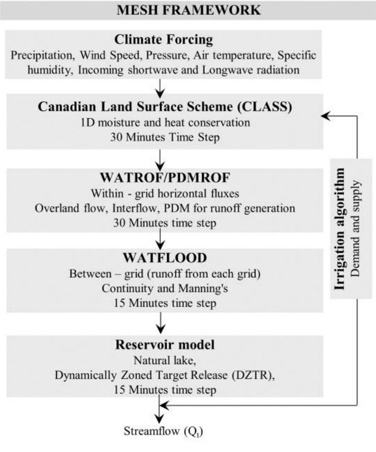
MESH (Modélisation Environnementale communautaire - Surface Hydrology) is the hydrology land-surface scheme (HLSS) of Environment and Climate Change Canada's (ECCC's) community environmental modelling system and is complimentary to ECCC's GEM-Hydro modelling platform. MESH allows different surface component models to coexist within the same modelling framework so that they can easily be compared for the same experiment using exactly the same forcings, interpolation procedures, grid, time period, time step and output specifications. An important feature of MESH is its ability to read atmospheric forcings from files instead of obtaining them from an atmospheric model. This makes it possible to test changes to the land surface schemes offline and to drive the HLSS with forcing data from other sources such as direct observations or reanalysis products.
MESH represents hydrological processes within a basin with three major components: (a) a vertical exchange of water and energy within a grid cell, (b) surface and subsurface runoff generation, and (c) the routing of lateral fluxes. MESH uses the Canadian land surface scheme (CLASS) or the soil, vegetation, and snow scheme (SVS) for the vertical exchanges and generation of lateral fluxes of water and energy for vegetation, soil and snow. The lateral soil (subsurface) and surface water movement are simulated by either WATROF or PDMROF. A sloped hillslope concept is used in WATROF where overland flow and interflow are represented by the Manning's equation and the Richard's equation, respectively. However, for the prairie pothole regions, which consist of thousands of shallow wetlands (also known as potholes) that only drain in wet years through the spill and fill mechanism, the PDMROF module is used. The PDMROF module calculates the storage and runoff in the prairies by applying the concept of the probability distributed model developed by Moore (2007). The streamflow through the river channels is routed using the WATROUTE module, which uses the continuity equation and Manning's formula to relate outflow from the channel to storage. MESH uses the grouped response unit approach for computational efficiency to simplify the description of large, complex and spatially heterogeneous basins by grouping together areas with similar physical characteristics such as land cover and/or soil type, making it a semi-distributed model.
Documentation
https://mesh-model.atlassian.net/wiki/
References
-
Pietroniro et al. (2007). Development of the MESH modelling system for hydrological ensemble forecasting of the Laurentian Great Lakes at the regional scale. Hydrology and Earth System Sciences Discussions, 11(4), 1279-1294.https://doi.org/10.5194/hess-11-1279-2007
License
MESH is open source software.
SUMMA
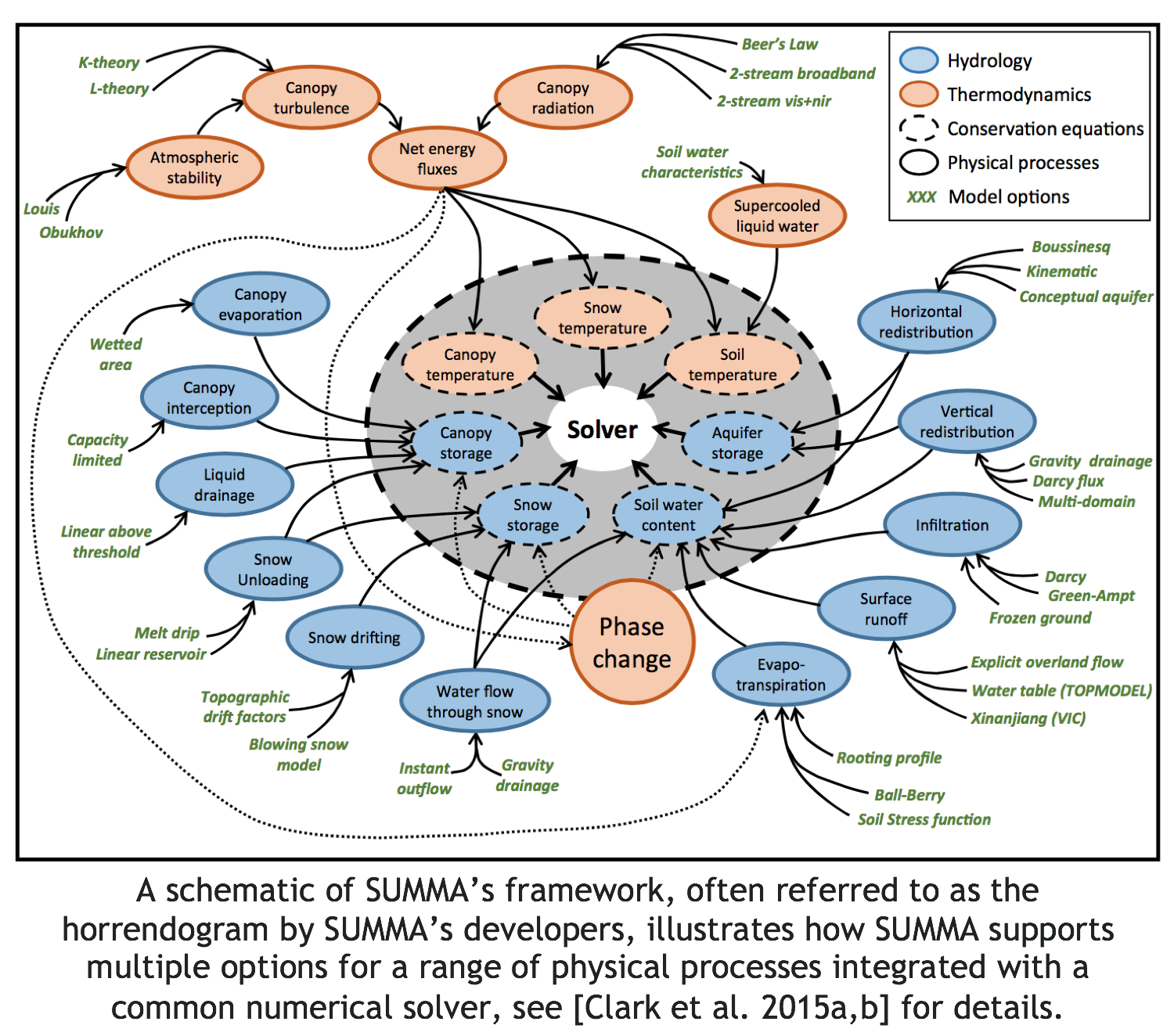
Structure for Unifying Multiple Modeling Alternatives (SUMMA) is a hydrologic modeling framework that can be used for the systematic analysis of alternative model conceptualizations with respect to flux parameterizations, spatial configurations, and numerical solution techniques. It can be used to configure a wide range of hydrological model alternatives and we anticipate that systematic model analysis will help researchers and practitioners understand reasons for inter-model differences in model behavior. When applied across a large sample of catchments, SUMMA may provide insights in the dominance of different physical processes and regional variability in the suitability of different modeling approaches. An important application of SUMMA is selecting specific physics options to reproduce the behavior of existing models – these applications of "model mimicry" can be used to define reference (benchmark) cases in structured model comparison experiments, and can help diagnose weaknesses of individual models in different hydroclimatic regimes.
SUMMA is built on a common set of conservation equations and a common numerical solver, which together constitute the “structural core” of the model. Different modeling approaches can then be implemented within the structural core, enabling a controlled and systematic analysis of alternative modeling options, and providing insight for future model development.
The important modeling features are:
-
The formulation of the conservation model equations is cleanly separated from their numerical solution;
-
Different model representations of physical processes (in particular, different flux parameterizations) can be used within a common set of conservation equations; and
-
The physical processes can be organized in different spatial configurations, including model elements of different shape and connectivity (e.g., nested multi-scale grids and HRUs)
Documentation
SUMMA documentation is available online and remains a work in progress. Additional SUMMA information including publications, test data sets, and sample applications can be found on the SUMMA web site at NCAR.
References
-
Clark et al. (2015a). A unified approach for process-based hydrologic modeling: Part 1. Modeling concept. Water Resources Research, doi:10.1002/2015WR017198.
-
Clark et al. (2015b). A unified approach for process-based hydrologic modeling: Part 2. Model implementation and case studies. Water Resources Research, doi:10.1002/2015WR017200.
License
SUMMA is distributed under the GNU Public License Version 3. For details see the file COPYING in the SUMMA root directory or visit the online version.
VIC-GRU
The VIC model was developed as a simple land surface/hydrological model that has received applications worldwide. Traditionally, the VIC model (version 4 and earlier) simulates sub-daily energy variables with daily forcing of minimum and maximum temperature, precipitation and wind speed. This enables the VIC model to be easily forced with hydrological available data sets worldwide while being able to solve the energy fluxes over sub-daily time periods. The VIC model combines sub-grid probability distributions to simulate surface hydrology such as variable infiltration capacity formulation with bio-physical formulations for transpiration. The VIC model is typically applied at regular grid. The modeler selects a cell size, and then the soil, vegetation and forcing files are all aggregated or disaggregated to the target cell size. Original data resolution and spatial distribution of soil, land cover and forcing data are lost.
In VIC-GRU, the VIC model is configured using non-regular shapes, i.e. Grouped Response Units (GRUs) that depends on the soil, vegetation, and topography. The GRUs hence describe unique characteristics of soil, vegetation type, elevation, slope and aspect. These GRUs then can be forced at the original resolution of forcing, or upscaled or downscaled values. Computational units can then be constructed that intersect the GRUs with the forcing grid. Therefore, each computational unit has unique geospatial data such as soil, vegetation, slope and aspect and is forced with a unique forcing (a specific GRU forced with unique forcing).
https://www.hydrol-earth-syst-sci-discuss.net/hess-2020-111/