
The GWF Planetary Water Prediction (PWP) Initiative
The PWP initiative will advance the computational infrastructure (datasets, modeling capabilities) necessary to produce global-domain simulations and predictions of hydrological risks. Moreover, PWP will use these state-of-the-art modeling capabilities to develop new and strategic collaborations with organizations and countries, through mutually beneficial, internationally focussed projects. PWP will involve collaboration with countries in the Americas, Asia, Africa, and Europe to develop, support, test, and apply coupled climate–hydrology–water quality–water management models globally with an emphasis on river basins where high mountain water supplies feed local and downstream water demands, and ecosystem needs.
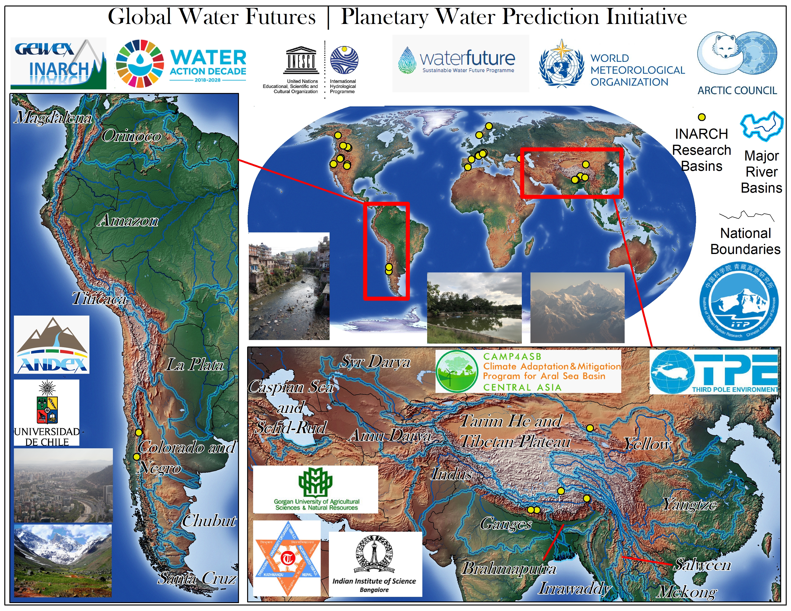
This document provides a basic framework and plan for implementing and carrying out the PWP initiative under GWF’s core modelling program. The plan is comprised of both global-domain projects to be implemented using available global data products and covering all regions across the world, and regionally nested and more focused applications in select areas where collaborations exist or are developed, and where targeted goals and questions will be addressed such as addressing the WMO Call for Action. Therefore, major areas of international collaboration and support with GWF will primarily focus on high mountain and cold regions, which are the recognized strengths of GWF. This is a 3-year plan (2020–2023) to conduct the PWP initiative throughout the remainder of the GWP Program.
Research plan
GWF will be ambitious in its efforts on global hydrology simulation. The need to understand the vulnerability of global water resources are varied but clearly crucial to meet the demands of the global community in managing the world’s most important resource. Current state-of-the-art systems are still largely based on mechanistic models that have been shown to be insufficiently sensitive and unable to capture the important processes in cold regions. Canada has shown global leadership through its GWF modelling efforts and we have an important obligation to assist in furthering understanding the global hydrological cycle.
As described above, the research will be focused around two inter-related activities: First, we will build the computational infrastructure (models, data) to enable state-of-the-art hydrological simulations anywhere on the planet. This will involve assembling and improving global datasets on climate forcing, DEMs, veg, soil etc., and using these datasets to configure hydrological models for the global domain. Second, we will develop regional models in key regions where we have strong collaborations (Arctic, Himalaya, Andes, central Asia) to address pressing societal needs. The regional models will be constructed as cut-outs from the global-scale fabric, and the global instantiations will used as a baseline to systematically evaluate the benefits of specific regional information (e.g., regional DEMs).
a. Global Simulations
The global projects will focus on the collection and use of global datasets for worldwide modelling application. These efforts will provide global coverage and results that can serve as baseline or initial information, which can be examined subsequently in more detail where specific questions or needs arise. The global verification efforts (e.g., iLAMB -- https://www.ilamb.org/) will be used to understand model weaknesses, compare our simulations to a suite of other land models, and improve modelling capabilities.
These global analyses would in turn improve the regional simulations. The users for this global effort would be the groups engaged in the global discussion on water security and climate change (e.g., COP).
The key tasks are as follows:
i. Global geospatial intelligence
This activity will involve the collection and assembly of global geospatial data (terrain, forcing and evaluation datasets, etc.), and the setup and preparation of hydrological and hydraulic models (routing, parameterization, basin delineation, etc.). This work will link to many of the activities as described within the GWF core modelling plans for Year 3 and beyond, in particular including: 1) Geospatial Intelligence, 2) Spatial Meteorological Forcing Data, and 3) Model Calibration, Sensitivity Analysis, and Benchmarking.
ii. Global hydrology and water management simulation system
This activity will advance the current generation MESH computational infrastructure (datasets, modeling capabilities) necessary to produce global-domain simulations/predictions of hydrological risks, including predictions of extreme hydrological events (droughts, floods) as well as assessments of water security. As part of this effort, human impacts on the terrestrial water cycle (such as reservoirs and irrigation) will incorporated within the global model. This work will link to the Water Resources Modeling for Large Domain Model Applications activities as described within the GWF core modelling plans for Year 3 and beyond.
iii. Global CHM (Canadian Hydrological Model) on snow and glaciers
This activity will be a proof of concept for CHM globally and will identify deficiencies in the system through stress testing and sensitivity analyses. It will provide a global snow and ice forecast, building on the pilot SnowCast system (http://www.snowcast.ca/) and applying this across all cold regions. This work will link to the Next-Generation Modelling activities as described within the GWF core modelling plans for Year 3 and beyond.
b. Regional Applications
Regionally focused and more targeted activities will be nested within the global project, depending on local stakeholder needs and requirements. These activities will involve collaborations with local partner institutions and researchers, often via GWF Projects, with specific agreements and terms, data sharing arrangements, local logistical support, and local stakeholder engagement and knowledge mobilization efforts. Where practical and feasible, there will be exchanges between local host countries and the host GWF institution, and an emphasis on local capacity building and training.
The activities include regional forecasting, diagnostic and predictive modelling of hydrological systems, and climate sensitivity analyses for the purpose of informing local management, decision making, and policy development, and strengthening local resilience to anticipated changes. Projects will require current generation model setup (MESH, CRHM) and initial testing, calibration and validation, and climate scenario analyses to examine impacts and management concerns. Effort will expand over time to include state-of-the art findings derived from the GWF pillar and core functions, to test these advancements with our partner institutions in the regional domains. These efforts will focus on four key regions, including the Arctic drainage basin, the Andes of South America, the Asian highlands of the Hindu-Kush-Himalaya and Tibetan Plateau, and Central Asia. Other potential high mountain regions may include East Africa and the Atlas Mountains. This will also involve regional water quality/water management modelling as needed and possible.