
Baker Creek Research Basin
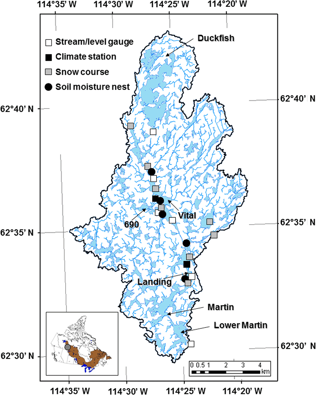
The Baker Creek Research basin is located in the subarctic Canadian Shield landscape of Canada's Northwest Territories near the city of Yellowknife. Baker Creek is a stream characterized by lakes connected by short channels that drains water from ∼165 km2 at its outlet into Great Slave Lake. There are 349 perennial lakes in the basin, with many being small, and the median and mean lake areas are 5400 and 88 800 m2, respectively. The basin is in the zone of discontinuous permafrost. Large changes in topography, vegetation, winter snow accumulation, local hydrology and surficial geology over short distances result in abrupt transitions from permafrost to non-permafrost conditions. Glaciolacustrine clays, outwash and organic deposits are typically underlain by permafrost, whereas bedrock and well-drained glaciofluvial sands are typically unfrozen. The thickness of organic soils or fine-grained materials derived from glaciolacustrine sediments, glaciofluvial sands or outwash range from less than 1 m to more than 10 m, depending on underlying bedrock topography. Well- and ground-thermistor string installations associated with this dataset rarely involve drilling greater than 10 m before encountering bedrock. An organic soil layer of about 0.25 m is ubiquitous over fine-grained soils. Any forest canopy that grows in these areas is typically quite open. Predominant vegetation includes black spruce (Picea mariana), jack pine (Pinus banksiana), paper birch (Betula papyrifera), Labrador tea (Ledum groenlandicum), moss (Sphagnum spp.) and lichen (Cladonia spp.).
Spence, C. and Hedstrom, N. (2018). Hydrometeorological data from Baker Creek Research Watershed, Northwest Territories, Canada, Earth Syst. Sci. Data, 10, 1753–1767, https://doi.org/10.5194/essd-10-1753-2018
Brightwater Creek Research Basin
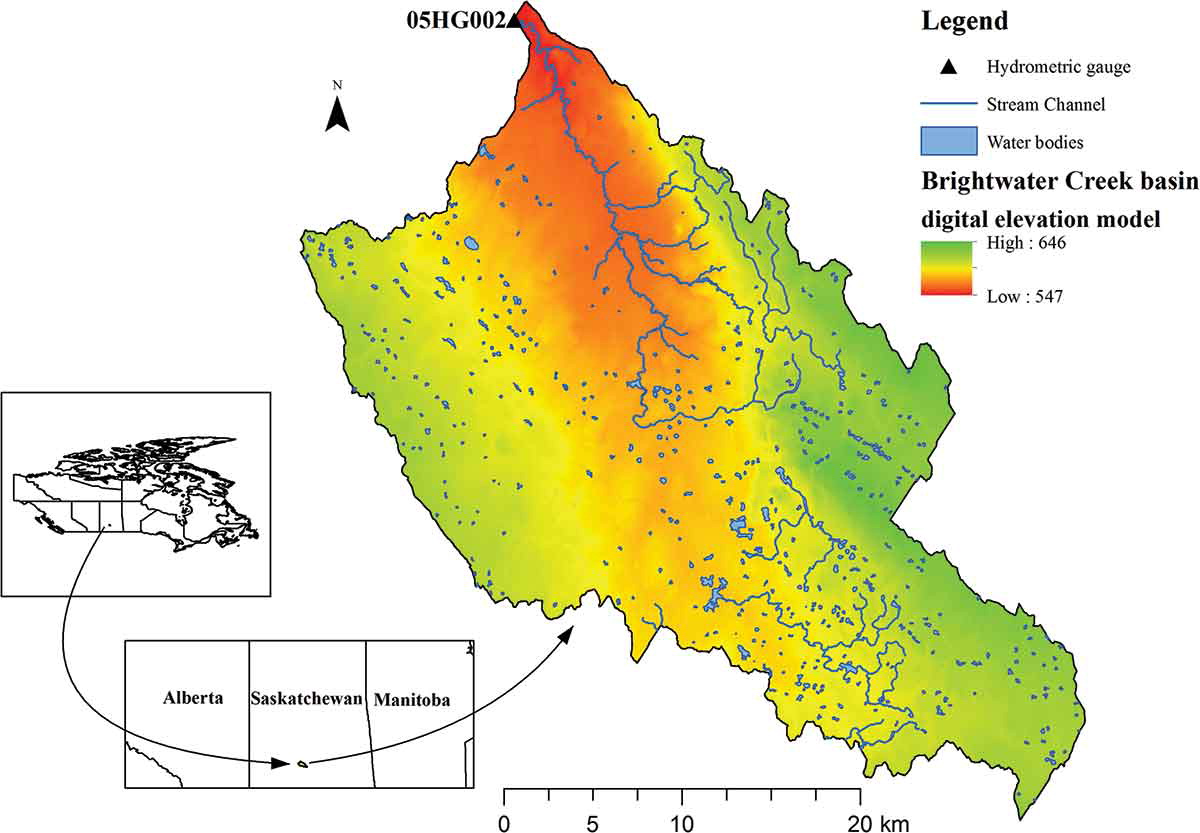
The Brightwater Creek (BWC) Resarch basin lies within the sub-basin of the South Saskatchewan River Basin, located in the prairies in the central Saskatchewan in Canada. The BWC has a gross drainage area of 864 km2 and a contributing area of 193 km2. The contributing drainage area is the part of the basin which contributes to the surface runoff under average runoff conditions. More than 75% of the total area in BWC consists of numerous potholes that do not contribute to the generation of streamflow, and therefore they are referred to as non-contributing drainage areas. The climate is semi-arid, with a mean annual precipitation of about 330 mm (2009–2014), falling typically 20% as snow. The streamflow is seasonal and mainly originates from snow melt during the spring period. The mean air temperature in January (winter) is −12.9°C and in July (summer) is 18.8°C. The soil texture of the site ranges from loam to clay loam, while the land cover predominantly comprises cropland (cereals, oilseeds, pulse crop), with some patches of various native grasses (such as wheatgrass and needle grass).
Budhathoki, S., Rokaya, P., Lindenschmidt, K. E., & Davison, B. (2020). A multi-objective calibration approach using in-situ soil moisture data for improved hydrological simulation of the Prairies. Hydrological Sciences Journal, 65(4), 638-649, https://doi.org/10.1080/02626667.2020.1715982
Havikpak Creek Research Basin
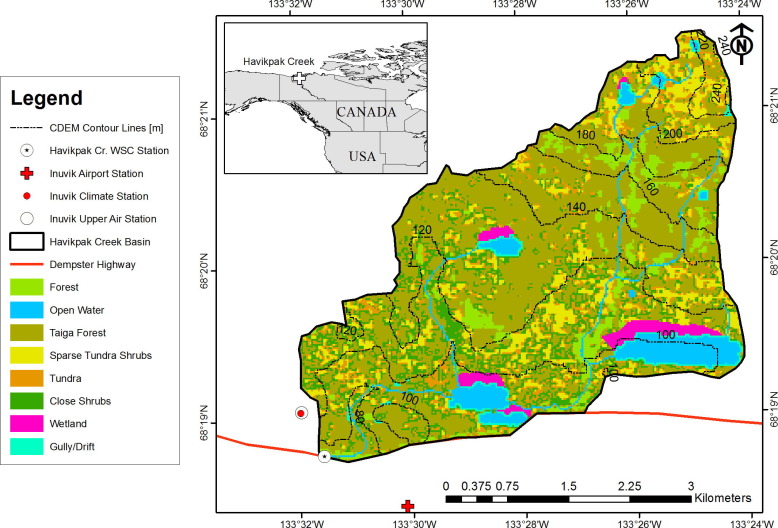
Havikpak Creek (HPC) Research basin is located a few kilometers north of the airport at Inuvik in Northwest Territories. The drainage basin is roughly 17 km2 in area. Surface cover is predominantly northern boreal forest, and the basin is within the continuous permafrost zone (with typically >20% ice content). The HPC has moderate topography (mean slope of approximately 2°) and an elevation range from 60 to 240 m, with a primary SW aspect. The majority of the forest in HPC is comprised of black spruce taiga (Picea mariana), primarily restricted to the mid-low elevations (<140 masl); however, a smaller area of forest can also be found on well drained hillsides and both shrub and some sparse tundra cover the highest elevations plateaux and gullies. The climate is subarctic, characterized by short summers and long cold winters, with an 8-month snow-cover period. Mean annual air temperature is about -10 °C and annual precipitation is about 266 mm (66% of which is snow).
Krogh, S. A., Pomeroy, J. W., & Marsh, P. (2017). Diagnosis of the hydrology of a small Arctic basin at the tundra-taiga transition using a physically based hydrological model. Journal of hydrology, 550, 685-703, https://doi.org/10.1016/j.jhydrol.2017.05.042
Marmot Creek Research Basin
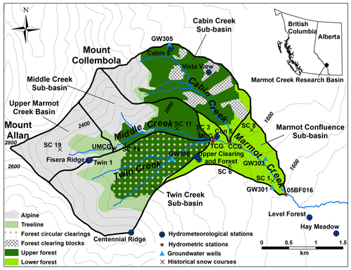
Marmot Creek Research Basin (MCRB) is in the headwaters of the Bow River basin in the Front Ranges of the Canadian Rocky Mountains and its streamflow discharges into the Kananaskis River. The basin area (9.4 km2) is defined by the Water Survey of Canada stream gauge that was installed in 1962. Elevation ranges from 1590 m a.s.l. at the main Marmot Creek gauging station to 2829 m at the summit of Mount Allan. Most of MCRB is covered by needleleaf vegetation, which is dominated by Engelmann spruce (Picea engelmannii) and subalpine fir (Abies lasiocarpa) in upper-mid elevations of the basin (1710 to 2277 m). The lower-elevation (1590 to 2015 m) forests are mainly Engelmann spruce and lodgepole pine (Pinus contorta var. Latifolia) with trembling aspen (Populus tremuloides) present near the basin outlet. Alpine larch (Larix lyallii) and short shrubs are present around the treeline at approximately 2016 to 2379 m. Exposed rock surfaces, grasses, and talus are present in the highest alpine part of the basin (1956 to 2829 m). The surficial soils are primarily poorly developed mountain soils consisting of glaciofluvial, surficial till, and postglacial colluvium deposits. Relatively impermeable bedrock is found at the higher elevations, whilst the rest of the basin is covered by a deep layer of coarse and permeable soil allowing for rapid rainfall infiltration to subsurface layers overlying relatively impermeable shale. Continental air masses control the weather in the region, which has long and cold winters and cool and wet springs with a late spring–early summer precipitation maximum. Annual precipitation ranges from 600 mm at lower elevations to more than 1100 mm at the higher elevations, of which approximately 70 % to 75 % occurs as snowfall with the percentage increasing with elevation. Mean monthly air temperature ranges from 14 ∘C observed at 1850 m in July to −10 ∘C observed at 2450 m in January.
Fang, X., Pomeroy, J. W., DeBeer, C. M., Harder, P., and Siemens, E. (2019). Hydrometeorological data from Marmot Creek Research Basin, Canadian Rockies. Earth Syst. Sci. Data, 11, 455–471, https://doi.org/10.5194/essd-11-455-2019
Peyto Glacier Research Basin
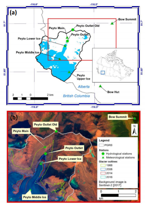
The Peyto Glacier Research Basin (PGRB) is in the Canadian Rockies, on the eastern side of the Continental Divide, at latitude 51.67 N and longitude 116.55 W. This heavily glacierized basin is 23.6 km2 in area, ranging in elevation from 1907 to 3152 m. It is located in a predominantly sedimentary geological region, with surrounding mountains formed from hard, resistant dolomite). The basin has been well monitored over a 50-year observational period. During the 1960s, the area of the glacier was 13.4 km2, but it has been continuously losing mass and area since at least the 1920s, shrinking to an area of 9.87 km2 as of 2018. Repeat ground-based photography from 1902 and 2002 show the glacier retreat that has occurred over the 20th century. A new proglacial lake has since formed at the tongue of the glacier that increases in size every year and has been informally named ‘Lake Munro’ by USask to honor D. Scott Munro’s research contribution to the glacier basin. Peyto Creek flows out of Lake Munro, draining the PGRB into Peyto Lake, thus supplying water to the Mistaya River.
Pradhananga, D., Pomeroy, J. W., Aubry-Wake, C., Munro, D. S., Shea, J., Demuth, M. N., ... & Mukherjee, K. (2020). Hydrometeorological, glaciological and geospatial research data from the Peyto Glacier Research Basin in the Canadian Rockies. Earth System Science Data Discussions, 1-35, https://doi.org/10.5194/essd-2020-219
Smith Creek Research Basin
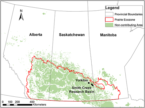
The Smith Creek Research Basin (SCRB) is located in southeastern Saskatchewan, Canada, approximately 60 km southeast of Yorkton, SK. The basin area is 393.4 km2 and is relatively flat with slopes fluctuating from 2% to 5% and elevation ranging from 490 m to 548 m. The dominant land use is agriculture (cropland and pasture) which encompasses approximately 48% of the basin. The remainder of the basin is comprised of native grassland, deciduous woodland and natural wetlands. Soil texture is predominately loam. The SCRB has been partially drained, with the extent of wetland area estimated to have decreased from 24% to 11% of the basin area from 1958-2008. Wetlands in this case are defined as depressional storage with either open water or exposed vegetation that are capable of storing water for at least several days. Interviews with farmers within the basin have reported that a higher-than-normal amount of drainage occurred in response to 1995 and 2011, years where major floods occurred. Rates of drainage are discussed in more detail later in the report. Many road culverts have been installed within the SCRB and act to help control the flow of water. These gates are managed by the rural municipalities (RM’s) and are typically left open, except during periods of high runoff (i.e., intense rainfall events, rapid snowmelt).
St. Denis National Wildlife Area
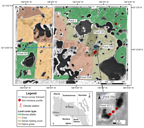
The St. Denis National Wildlife Area (SDNWA) is located in the seasonally frozen and semi-arid Canadian Prairies, close to Saskatoon, Saskatchewan. The site has a hummocky terrain and is underlain by clay-rich glacial tills. Though the site is only 4 km2 it contains hundreds of wetlands containing ponds which range in size, in permanence (from ephemeral to permanent), and in their interactions with groundwater (recharge and discharge ponds are present). The SDNWA and surrounding landscape area is hummocky, with local relief of the order of 15 m. The area lies within and near the lower end of a 2400 ha closed watershed. Aspen bluffs occupy some of the larger depressions in the drainage basin. Three main land uses exist at this site: native grasslands, brome grasslands (Bromus inermis) and cultivatedlands. The dominant native grasses are spear grass (Stipa spartea), wheat grass (Agropyron dasystachyum) andfescue (Festuca scabrella). Soils are predominantly Dark Brown Chernozems and Orthic Regosols; both are developed from glacial till. The glacial stratigraphy of the site is well-documented: roughly 100 m of clay-rich glacial till of low permeability lies under the soils, interspersed with isolated sand lenses and a continuous thin layer of sand at about 25 to 30 m depth. The annual mean air temperature is 2°C, with monthly means of -19°C in Januaryand 18°C in July. The annual evaporation from large lakes in this area is 690–710 mm, based on data from Last Mountain Lake located 100 km south-east of the study site.
Bam, E. K., Brannen, R., Budhathoki, S., Ireson, A. M., Spence, C., & Kamp, G. V. D. (2019). Meteorological, soil moisture, surface water, and groundwater data from the St. Denis National Wildlife Area, Saskatchewan, Canada. Earth System Science Data, 11(2), 553-563, https://doi.org/10.5194/essd-11-553-2019
Wolf Creek Research Basin
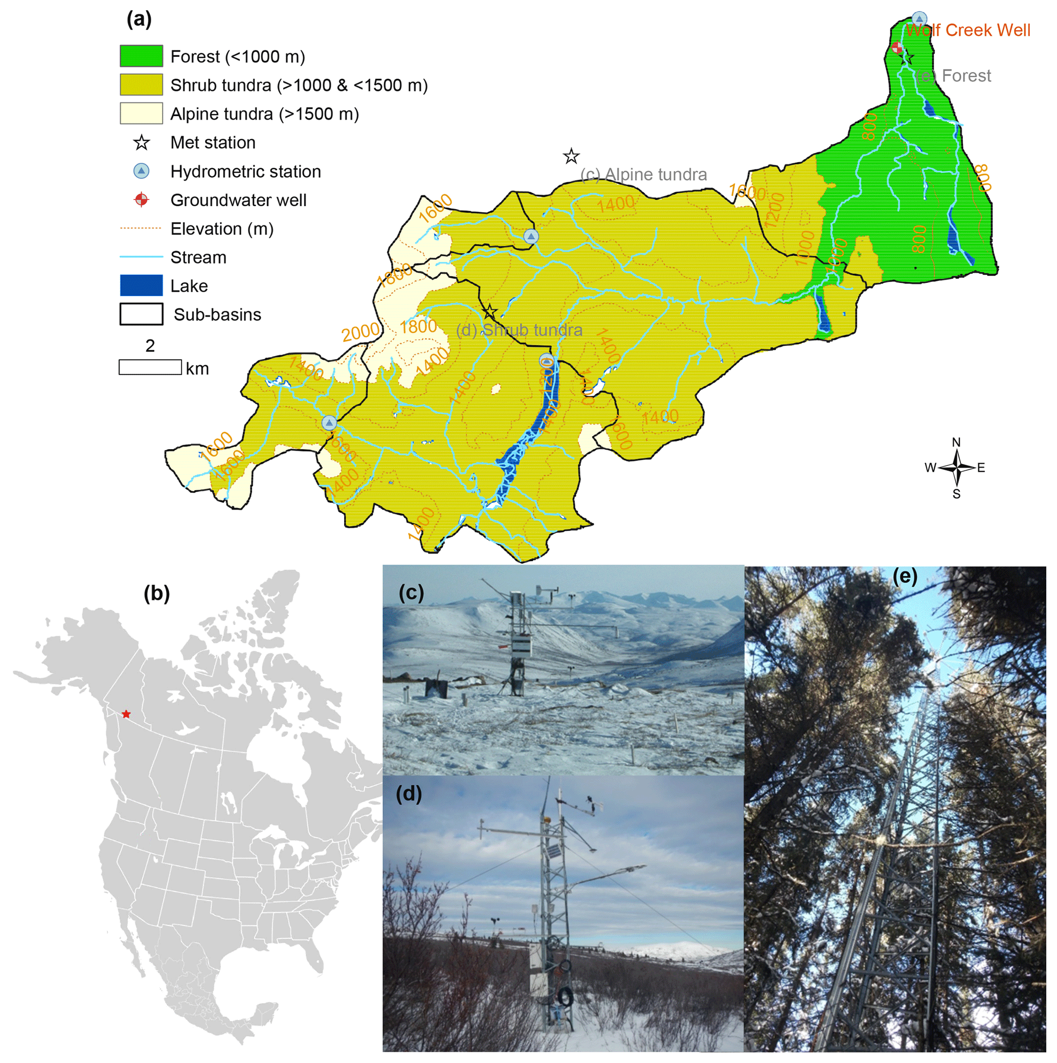
The Wolf Creek basin forms part of the southern headwaters of the Yukon River, among mountains some 20km south of Whitehorse. The basin drains an area of approximately 195km2, ranging in elevation from 800 to 2250m, with the median at 1325m, and a general north-easterly aspect. The basin is situated within the Boreal Cordillera ecozone, and consists of three principal ecosystems; boreal forest (22%), sub-alpine taiga (shrub-tundra) (58%), and alpine tundra (20%). Permafrost is present on north facing slopes and sporadically throughout the basin, with prevalence increasing with elevation. The sub-arctic continental climate is characterized by wide seasonal variation in temperature, low relative humidity and relatively low precipitation. Mean annual temperature is approximately -3ºC, with summer monthly ranges of 5ºC - 15ºC, and and winter monthly ranges of -100ºC to -20ºC. Summer and winter extremes of 25ºC and -40ºC are not uncommon. Mean annual precipitation is 300 to 400 mm per year, with approximately 40% of this falling as snow. Three micrometeorological stations (Alpine Tundra, Buckbrush Taiga, and White Spruce Forest) were established to collect and store weather and soil data. A hydrometric station located at the Wolf Creek basin outlet nearby the Alaska Highway was used to record the basin discharge. Several additional sites were also established in a sub-basin (the Granger Basin, approximate area 4.3 km2), in order to study energy and water balances on sloped surfaces. Three sub-basins are gauged for streamflow.
Rasouli, K., Pomeroy, J. W., Janowicz, J. R., Williams, T. J., & Carey, S. K. (2019). A long-term hydrometeorological dataset (1993–2014) of a northern mountain basin: Wolf Creek Research Basin, Yukon Territory, Canada. Earth System Science Data, 11(1), 89-100, https://doi.org/10.5194/essd-11-89-2019