
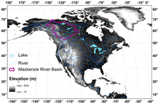
Mackenzie River basin
Saskatchewan River basin
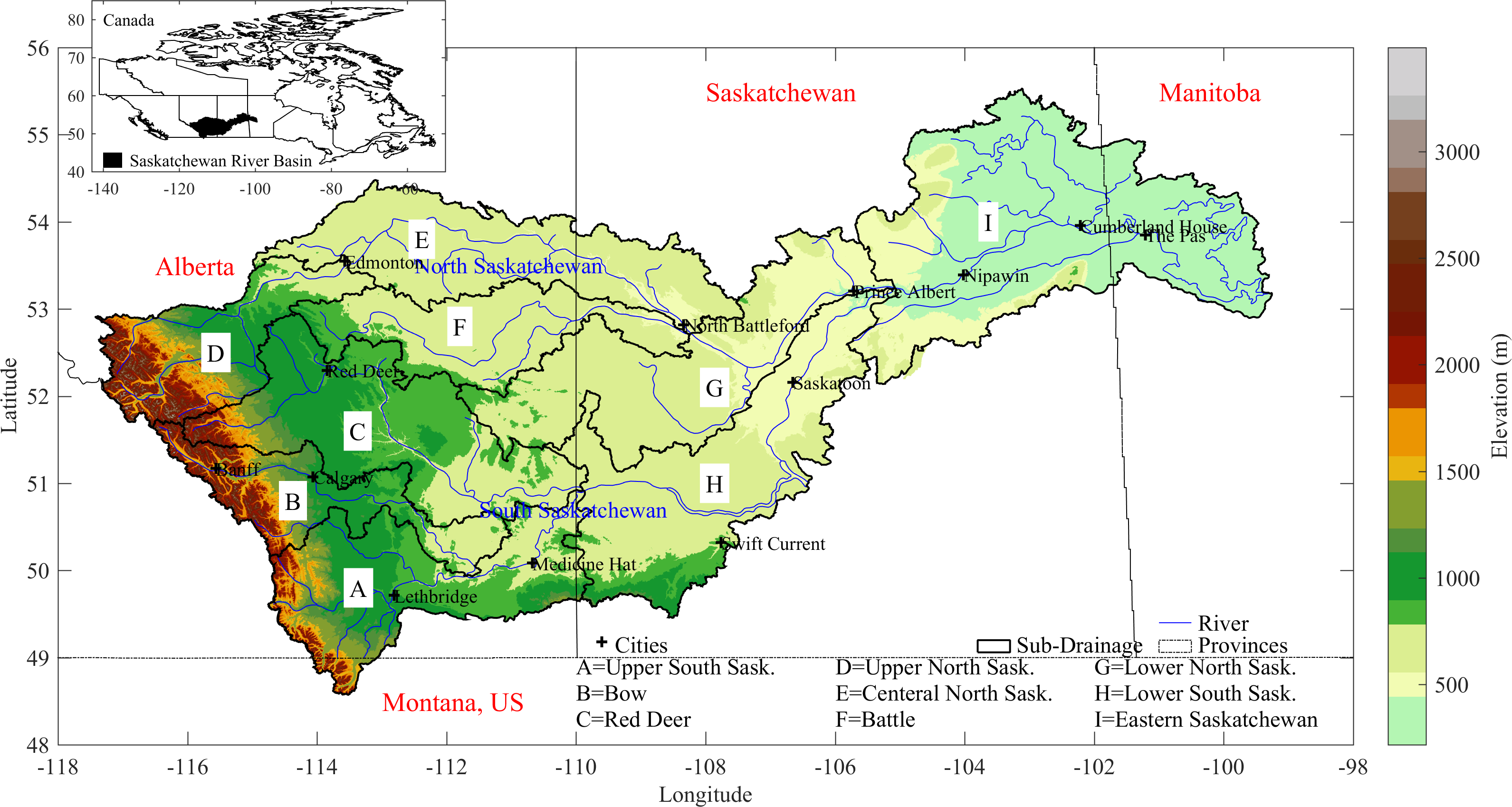
The Saskatchewan River Basin (SaskRB) encompasses portions of the Canadian provinces of Alberta, Saskatchewan, and Manitoba, as well as a small portion of the US state of Montana. The SaskRB is situated in western Canada (98° - 118° W and 48° – 56° N), with a total drainage area of 406,000 km2 and approximate maximum dimensions of 1300 km east-west and 700 km north-south. The source of the SaskRB originates in the eastern slopes of the Canadian Rockies in Alberta, which 25 includes parts of the Columbia Icefield. The two main tributaries of the SaskRB are the South and North Saskatchewan Rivers, both of which flow east and northeast through the Saskatchewan Prairies, before merging to form the Saskatchewan River, flowing through the Saskatchewan Delta (North America’s largest freshwater inland delta), and draining into Lake Winnipeg in Manitoba. The two tributary river systems are further subdivided into nine subbasins of the Bow, Red Deer, Battle, Upper North, Central North, Lower North, Upper South, Lower South, and Eastern Saskatchewan rivers. The Upper South basin can further be disaggregated into the Oldman basin and a small watershed draining from Montana, US.
The topographic elevation of the basin ranges between 218 and 3487 m above sea level. The physiographic characteristics extend from the rugged Canadian Rocky Mountains, foothills, and uplands on the far western side of the basin to lowlands and plains in the remaining parts of the basin. The Ecozones of the SaskRB are classified into four ecozones; Montane Cordillera, Prairie, Boreal Plain, and Boreal Shield, covering 6, 58, 33, and 3 % of the basin area respectively. The Montane Cordillera Ecozone encompasses all the rugged mountains of the basin, the Boreal Plain has gently rolling to level topography, and the Boreal Shield contains hilly terrain with numerous ponds, wetland, and lakes. The Prairie Ecozone covers post-glacial undulating plains to rolling plains and flat terrain with numerous depressional areas. The Prairie have several unique features: the pothole topography prevents some areas from draining to the major river system, the ecozone has internal drainage, and connection to the major river system are intermittent. The parts of the ecozone not draining to the major river system are commonly called “non-contributing areas”, defined as the drainage areas not playing a part in runoff in a flood that has a two-year return period.
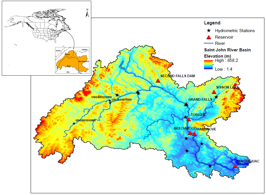
St. John River basin
Fraser River basin
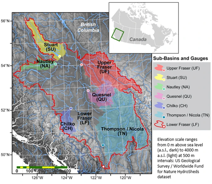
The snow-dominated Fraser River basin (FRB) of British Columbia (BC) is one of the largest and most important watersheds of Western North America. The FRB basin covers around 240,000 km2, spans one-fourth of BC, and thus forms the greatest salmon rivers with important environmental, economic, and cultural value. This watershed drains 11 different biogeoclimatic zones, from dry interior plateaus to wet, snowy mountains in its headwaters of the northern Rockies, the Columbia and Coast Mountains and thus integrates a diverse mosaic of landscapes, weather, and climate. Some of the major tributaries of the Fraser River are the Nechako, Quesnel, Chilcotin, and Thompson Rivers within the interior plateau. Descending through the Fraser Canyon, the Fraser River reaches Hope, BC, and then veers westward into the Salish Sea and the Strait of Georgia at Vancouver, BC. The central sections of the Fraser River are mostly forested, but the area also includes grassland vegetation and large cattle farms in the relatively dry interior plateau while glaciers abound in the Rocky, Cariboo, and Coast Mountains. The main stem Fraser River has no impoundments, but the ~45 000 km2 Nechako River basin, a main tributary in the northwestern part of the FRB, is a heavily regulated system.
Across the FRB, mean annual air temperatures vary from 0.5°C in the northwestern boundary in the Skeena Mountains to 7.5°C in the south near the Okanagan area. The ranges of mean summer air temperature in the FRB are less variable (11° to 16.5°C) than the winter mean air temperature (−11° to −1°C). Precipitation is highly variable across the study domain. Coastal and mountainous areas receive abundant precipitation amounts of up to 3000 mm yr−1 while the interior plateau and regions to the lee of the Coast Mountains receive 400–800 mm yr−1. In the northern and mountainous regions of the FRB, snowfall plays an important role in precipitation. Because of its highly varying terrain and climate, the FRB includes various vegetation and land cover types ranging from alpine terrain, subalpine, and montane and coastal forests, with drier inland forests and grasslands in the interior plateau.
Columbia River basin
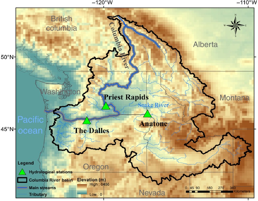
The Columbia River originates in the southern Canadian Rockies at the Columbia Icefield in Jasper National Park. The basin is 668,000 km2 and contributes more water to the Pacific Ocean than any other North and South American river. The Columbia River basin is divided into two parts by the north–south‐trending Cascade Mountain Range, namely, the western sub‐basin with area of 46 650 km2 where the Willamette River is the largest drainage and the interior sub‐basin covering 613,830 km2 which lies in east of the Cascade Range. The interior sub‐basin primarily consists of the Upper Columbia and the Snake River, and 97% of the total interior sub‐basin streamflow is gauged at Dalles station. Annual precipitation of the Columbia River basin increases from east to west, ranging from <250 mm year−1 over the Columbia plateau and the Snake River basin to >2550 mm year−1 in the coastal area. Although the western sub‐basin accounts for only 7% of the basin area, it contributes approximately 25% of the total runoff. Streamflow in the western sub‐basin occurs mostly coming from winter precipitation, from November to March. Conversely, the flow of the interior sub‐basin mostly occurs during the spring snowmelt, from April to July. Because the interior sub‐basin has a large drainage area, it encompasses remarkable precipitation variations.
Great Lakes basin
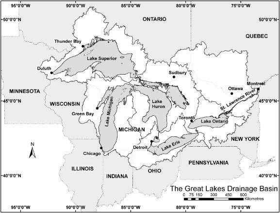
Located in North America between Canada and the United States, the Great Lakes are composed of five interconnected large lakes namely, Superior, Michigan, Huron, Erie, and Ontario. The entire watershed system has a drainage area of nearly 1 million square kilometres and includes one small lake called St. Clair (between Lake Huron and Lake Erie), four connecting channels (St. Marys, St. Clair, Detroit, and Niagara rivers), and the St. Lawrence River. The entire drainage basin along with the drainage areas associated with each lake and the St. Lawrence River. The basin is the largest source of surface freshwater in the world - it contains over 21% of the world’s surface freshwater and is the primary water source for over 15 million Canadians and 30 million Americans. The five Great Lakes – Superior, Michigan, Huron, Erie, and Ontario – and the St. Lawrence River are bordered by eight US states and two Canadian provinces. The St. Lawrence River runs from Niagara Falls to the Gulf of St. Lawrence, passing through the provinces of Ontario and Québec. The river links the Atlantic Ocean with the Great Lakes and is among the world’s most important commercial waterways.
Yukon River basin
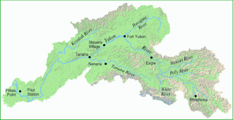
The Yukon has a drainage area of 840 000 km2. It is 3185-km long, with 1149 km in Canada. The Yukon River rises from the Atlin Lake and flows northwest to Fort Yukon, and then turns southwest and enters the Bering Sea. Its major tributaries are the Teslin, Pelly, White, Stewart, Porcupine, Tanana, and Koyukuk rivers. The Yukon basin consists of 37% rolling topography and gentle slopes, 24% low mountains 20% plains and low mountains, 17% moderately high rugged mountains, and 2% extremely high rugged mountains. The Yukon River is one of the largest rivers in the northern regions. It contributes 203 km3 year−1 freshwater to the Bering Sea. It is the fifth-largest river in terms of annual total discharge in the northern regions. Hydrologic conditions and its changes in the Yukon River significantly affect regional biological and ecological systems. The US Geological Survey and Environment Canada maintain a hydrologic network in the Yukon River basin. Large dams and reservoirs were built in the northern regions for power generation, flood control, and irrigation. Studies show that reservoirs’ regulation alters hydrologic regimes particularly in the regulated sub-basins. There are no large dams in the Yukon basin; discharge data collected over this basin are reliable indicators of climate change and variation. The USGS produced a report to document the major hydrologic patterns within the basin.